 GTA 6 Map
Under the bridge spots on the GTA 6 map
Landmarks202 markers
This site lists 202 under the bridge spots. The largest counts are in Vice City (81), Ambrosia (34) and Grassrivers (28). The source data marks none of the positions as unconfirmed. Positions come from Open GTA 6 Map. This site has not checked them against the game.
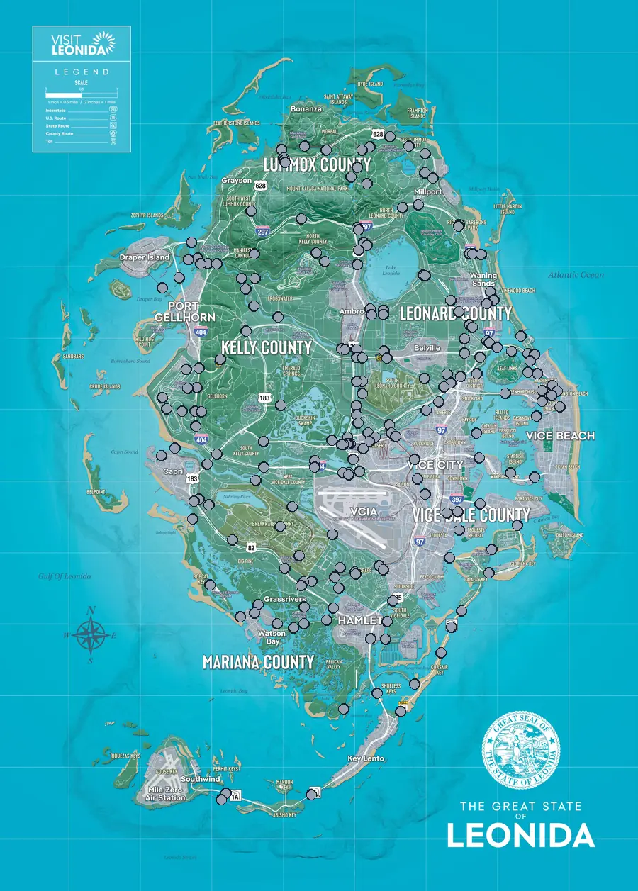
Vice City 81
- Bluegrass Railroad BridgeI6
- Bonita Court Footbridge Vice BeachF8
- Casanova Island Bridge Vice BeachG8
- Delamore Bridge Vice BeachF8
- Oleander Bridge Vice BeachF8
- Port VC Bridge Vice CityH7
- Rivo Bridge Vice CityG7
- S-17 Canal Drawbridge Central Vice CityF7
- S-17 Canal Drawbridge North Vice CityF7
- S-17 Canal Drawbridge South Vice CityG6
- S-17 Canal Swing Bridge Vice CityG6
- Tequesta Bridge Vice CityH7
- Tisha-Wocka Flea Market Bridge Vice CityG5
- Under the Bridge: Ajax Gym / Lawton Theater Vice BeachF8
- Under the Bridge: Atlantic Avenue Vice BeachF8
- Under the Bridge: Atlantic Causeway Vice BeachF7
- Under the Bridge: Atlee River HamletI5
- Under the Bridge: Balsero Overpass Central Vice CityG5
- Under the Bridge: Balsero Overpass East Vice CityG6
- Under the Bridge: Balsero Overpass North Vice CityG5
- Under the Bridge: Balsero Overpass West Vice CityG5
- Under the Bridge: Belville Canal East Vice CityF7
- Under the Bridge: Belville East Overpass Vice CityF7
- Under the Bridge: Belville East Railroad Vice CityF7
- Under the Bridge: Belville Town Overpass Vice CityF7
- Under the Bridge: Bluegrass NorthI5
- Under the Bridge: Bluegrass South HamletI5
- Under the Bridge: Bright Maw Pass HamletJ6
- Under the Bridge: Buckskin Swamp Southeast Vice CityG5
- Under the Bridge: Catalan Boulevard Vice CityF7
- Under the Bridge: Catalan Key East Gloriana KeyH7
- Under the Bridge: Catalan Key SouthI7
- Under the Bridge: Catalan Key West Vice CityI7
- Under the Bridge: Del Rio Boulevard Vice CityF7
- Under the Bridge: Downtown Southeast Vice CityH7
- Under the Bridge: Downtown Southwest Vice CityH7
- Under the Bridge: Emory Avenue HamletI6
- Under the Bridge: Flamingo Parkway North Vice BeachE8
- Under the Bridge: Flamingo Parkway South Vice BeachF8
- Under the Bridge: Fleeca Field Stadium Vice CityG6
- Under the Bridge: Fuzzard Drain CanalI6
- Under the Bridge: Fuzzard Drain Canal Railroad East Vice CityI6
- Under the Bridge: Fuzzard Drain Canal Railroad WestI5
- Under the Bridge: Gloriana Key North Gloriana KeyH8
- Under the Bridge: Gloriana Key West Gloriana KeyI7
- Under the Bridge: Hamlet Overpass HamletJ6
- Under the Bridge: Leonida Auto World Vice CityG6
- Under the Bridge: Leonida Canal RailroadF6
- Under the Bridge: Leonida Canal SoutheastG6
- Under the Bridge: Leonida Canal SouthwestG6
- Under the Bridge: Leonida Power and Light Vice CityG6
- Under the Bridge: Macalister Causeway Vice CityG7
- Under the Bridge: Mariposa Avenue Vice BeachF8
- Under the Bridge: North Isla MaldiaJ7
- Under the Bridge: Oleander Boulevard Vice BeachF8
- Under the Bridge: Omega Parkway Vice CityG6
- Under the Bridge: Pelican River HamletI5
- Under the Bridge: RON Gas - Balsero Vice CityG6
- Under the Bridge: Salton Overpass Vice CityG6
- Under the Bridge: Seabell AvenueH5
- Under the Bridge: South Leonard County Railroad SouthF6
- Under the Bridge: South Vice-Dale County Overpass Vice CityI6
- Under the Bridge: Southside West Vice CityI6
- Under the Bridge: Starfish Island Vice CityG8
- Under the Bridge: Tidal Avenue Vice BeachF8
- Under the Bridge: Tish-Wocka Flea Market West Vice CityG5
- Under the Bridge: Tisha-Wocka Flea Market Central Vice CityG5
- Under the Bridge: Tisha-Wocka Flea Market East Vice CityG5
- Under the Bridge: Tybee Channel Mouth East Waning SandsF7
- Under the Bridge: Tybee Channel South Waning SandsF7
- Under the Bridge: Vice River North Vice CityG6
- Under the Bridge: Vice River South Vice CityG6
- Under the Bridge: Vineyard Drive East Vice BeachF8
- Under the Bridge: Vineyard Drive West Vice BeachF8
- Under the Bridge: Washington Beach West Vice BeachF8
- Under the Bridge: Waxman Island East Vice BeachG8
- Under the Bridge: West Royale Street Vice CityH6
- Under the Bridge: West Vice-Dale County North Vice CityG5
- Under the Bridge: West Vice-Dale County NortheastG5
- Under the Bridge: West Vice-Dale County SouthG5
- Washington Beach Footbridge Vice BeachF8
Leonida Keys 8
- Old Fort Road BridgeK5
- Saltrock BridgeL4
- Under the Bridge: Isla MaldiaJ7
- Under the Bridge: Keylime Causeway Key LentoL5
- Under the Bridge: Lento Causeway Key LentoJ6
- Under the Bridge: North Key Lento Key LentoK6
- Under the Bridge: Permit CausewayL4
- Under the Bridge: South Isla MaldiaJ6
Grassrivers 28
- Emerald Bridge CapriG3
- SND Station Footbridge Watson BayI5
- Under the Bridge: Bobcat Key Central Watson BayI3
- Under the Bridge: Bobcat Key North CapriH3
- Under the Bridge: Bobcat Key South Watson BayI4
- Under the Bridge: Breakwater QuarryH4
- Under the Bridge: Capri Bay Railroad CapriG3
- Under the Bridge: Capri Island CapriG3
- Under the Bridge: Caprice City Canal Vice CityH5
- Under the Bridge: Cargo RoadG5
- Under the Bridge: East Big Pine Watson BayI5
- Under the Bridge: East Watson BayI5
- Under the Bridge: Gavin's Creek East Watson BayI4
- Under the Bridge: Gavin's Creek West Watson BayI4
- Under the Bridge: Goliath Global QuarryI5
- Under the Bridge: Muspachee River EastG5
- Under the Bridge: Muspachee River WestG4
- Under the Bridge: Nehrling River East CapriH3
- Under the Bridge: Nehrling River Railroad CapriH3
- Under the Bridge: Nehrling River West CapriH3
- Under the Bridge: North Mariana County Overpass Watson BayI5
- Under the Bridge: North Mariana County Railroad Southeast Watson BayI5
- Under the Bridge: North Mariana County Railroad Southwest Watson BayI5
- Under the Bridge: North Mariana County Railroad WestH4
- Under the Bridge: North Watson Bay Watson BayI4
- Under the Bridge: South Kelly County Overpass CapriG4
- Under the Bridge: Terrapin RoadG4
- Under the Bridge: Watson Bay Watson BayJ5
Port Gellhorn 15
- Gowing Railroad Bridge Port GellhornE3
- Raceway Paddock Bridge Port GellhornF3
- Under the Bridge: Buckskin Swamp ChannelsF4
- Under the Bridge: Buckskin Swamp SouthwestG4
- Under the Bridge: Chepalle BillboardG3
- Under the Bridge: Draper Island South Port GellhornE3
- Under the Bridge: Gellhorn International Raceway Port GellhornF3
- Under the Bridge: Gellhorn Rally XF3
- Under the Bridge: Raceway Overpass CentralG3
- Under the Bridge: Raceway Overpass East Port GellhornF4
- Under the Bridge: Raceway Overpass North Port GellhornF3
- Under the Bridge: Raceway Overpass SouthG3
- Under the Bridge: Raceway Parking Port GellhornF3
- Under the Bridge: Raceway StandsF3
- Under the Bridge: Xero BillboardG3
Ambrosia 34
- Draper Island Bridge Port GellhornD3
- Graffiti BridgeE4
- Under the Bridge: Allied Crystal Pipeline AmbrosiaE6
- Under the Bridge: Ambrosia East Railroad North AmbrosiaE6
- Under the Bridge: Ambrosia East Railroad South AmbrosiaF6
- Under the Bridge: Belville Canal North AmbrosiaE6
- Under the Bridge: Belville Canal Railroad AmbrosiaE6
- Under the Bridge: Draper Island East Port GellhornD3
- Under the Bridge: Kalaga RiverD6
- Under the Bridge: Kalaga River Mouth AmbrosiaD6
- Under the Bridge: Kalaga River Railroad AmbrosiaD6
- Under the Bridge: Kelly River NorthE4
- Under the Bridge: Kelly River Railroad East AmbrosiaF5
- Under the Bridge: Kelly River Railroad West AmbrosiaF5
- Under the Bridge: Kelly River South AmbrosiaE4
- Under the Bridge: Leonida Canal AmbrosiaF6
- Under the Bridge: Leonida Canal North AmbrosiaF6
- Under the Bridge: Leonida Canal SouthF6
- Under the Bridge: North Frogswater RailroadD5
- Under the Bridge: North Gellhorn OverpassE4
- Under the Bridge: North Kelly County Overpass East AmbrosiaD6
- Under the Bridge: North Leonard County Overpass NorthD6
- Under the Bridge: Providence Canyon RailroadD4
- Under the Bridge: Saputka River Port GellhornD4
- Under the Bridge: Saputka River EastE4
- Under the Bridge: Saputka River Mouth AmbrosiaD6
- Under the Bridge: Saputka River RailroadE4
- Under the Bridge: Saputka River Railroad EastD5
- Under the Bridge: Saputka River Railroad North Port GellhornD3
- Under the Bridge: Saputka River Railroad West Port GellhornD3
- Under the Bridge: Saputka River West Port GellhornD3
- Under the Bridge: South Leonard County Railroad North AmbrosiaF6
- Under the Bridge: Tybee Channel North Waning SandsE6
- Under the Bridge: Tybee Channel Railroad North Waning SandsE6
Mount Kalaga 20
- North Kalaga BridgeC6
- Under the Bridge: East Lummox County OverpassC6
- Under the Bridge: Interstate 297 OverpassC6
- Under the Bridge: Kalaga ReservoirC5
- Under the Bridge: Kalaga River SouthC6
- Under the Bridge: Macalister Gold MineC5
- Under the Bridge: Macalister River CentralC6
- Under the Bridge: Macalister River NorthC6
- Under the Bridge: Millport OverpassC7
- Under the Bridge: North Kelly County Overpass WestD5
- Under the Bridge: North Leonard County OverpassD6
- Under the Bridge: North Leonard County RailwayD6
- Under the Bridge: South Kalaga OverpassC6
- Under the Bridge: Tallaloko RiverC6
- Under the Bridge: West Kalaga Overpass NorthC5
- Under the Bridge: West Kalaga Overpass SouthC5
- Under the Bridge: West Kalaga Overpass WestD4
- Under the Bridge: West Moreau OverpassC5
- Under the Bridge: West Moreau Railroad NorthC4
- Under the Bridge: West Moreau Railroad SouthC5
Leonard coast 16
- Evergreen Mall Bridge Waning SandsE7
- Under the Bridge: Belville Canal South AmbrosiaF6
- Under the Bridge: Belville North Railroad Waning SandsF7
- Under the Bridge: Caledonia BoulevardF6
- Under the Bridge: County Route 62 AmbrosiaF6
- Under the Bridge: Leith River Central Waning SandsE7
- Under the Bridge: Leith River NorthD7
- Under the Bridge: Leith River South Waning SandsE7
- Under the Bridge: Richard Barebone Overpass EastD7
- Under the Bridge: Richard Barebone Overpass WestD7
- Under the Bridge: Tybee Channel Central Waning SandsE7
- Under the Bridge: Tybee Channel Railroad South Waning SandsE7
- Under the Bridge: Waning Sands Central Waning SandsE7
- Under the Bridge: Waning Sands OverpassD7
- Under the Bridge: Waning Sands RailroadD7
- Under the Bridge: West Mall Drive Waning SandsE7
Region is the region of the nearest named place on the official map. Grid references use the poster's grid, one cell to the mile. Positions come from community datasets and are not checked against the game by this site.